|
Leaving our campsite in Mojave National Preserve early in the morning,
we drove north through Baker and toward Shoshone on highway 127. Near
Ibex Pass south of Shoshone, we started seeing numerous clumps of white
flowers mixed among the bushes, which we later determined were
desert chicory. We didn't stop, because we were in a hurry to
get to Death Valley proper. Reports of sweeping blooms in the
park had appeared starting in early February, and I was concerned
whether we would be "too late".
From Shoshone, we took highway 178 to the south entrance of Death
Valley National Park. Approaching Salsberry Pass,
the number and density of flowers was increasing.
A storm had come through just a few days before and had dropped
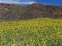
fresh snow on the highest peaks. We stopped on the east side of
the pass to look at the flowers, with the white-capped Spring Mountains
of Nevada shining about 50 miles to the east.
One of the great things about wildflowers in the desert is
the contrast with the barren rocky mountains and the great
sense of space due to the clean air and long distance views.
From Salsberry Pass onward, cars were pulled over at every
turnout with clumps of people admiring flowers near and far.
It was really an embarrassment of riches. Any place you stopped
to look yielded numerous species. I especially liked the way
that the desert chicory would grow through other bushes and
brighten them up, as if they too were flowering.
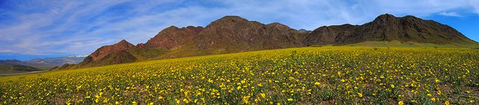
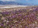
Cresting the low Jubilee Pass on the highway, the mountains to the
north and west
had a peculiar yellow-green tint covering their lower slopes and the
alluvial fans that swept downward from them to Death Valley itself.
Every minute of driving made it more clear that this was a large
flower field. We pulled over where there was a nice distant
view across a wash to a yellow covered fan. Leaving the rest of
the tourists standing by their cars, we walked about 1/4 mile
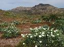
across the wash and into the flower field. Desert gold sunflowers
were everywhere, growing about 2 to 3 feet high from a totally
barren fan that had very few bushes.
The panorama at the top of this page was taken at that spot.
These flower fields were incredibly showy partly because the fans
themselves are normally just barren dirt and rock. All of the
flowering desert areas we had seen on the way here had numerous
creosote and other hardy bushes, with flowers scattered among them.
Here, it was just a solid sea of yellow sunflowers.
This view alone was worth the whole trip, but it continued.
Returning to our car and proceeding downhill toward Death Valley,
the road entered the field of sunflowers. Cars were parked
everywhere and everyone was a photographer, trying to somehow
capture the magic of this shining yellow sea. For several miles
to the old Ashfold Mill and beyond, views on both sides of the
road were of vast fields of sunflowers. Across the Amargosa
River -- a normally dry riverbed that was actually flowing --
the distant Confidence Hills and Shoreline Butte had that same
bright yellow-green color washing completely over them. I knew
that if we had the time to make the hike out to them, we would
find great fields of these sunflowers there, as well.
Beyond the Ashford Mills area, the flowers diminished, although
there were always scattered ones visible here and there. In
this stretch of the highway up to Badwater, the grandeur of
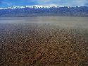
Death Valley itself took our attention. The heavy rains had
run off into the valley basin and flooded the normally dry salt
flats, recreating a miles wide Lake Manly that was only a few
feet deep, but set over 250 feet below sea level!
On the east (highway) side, the Black Mountains rose steeply
and dramatically with bands of colored rocks. Across the valley,
the Panamint Range rose to over 11,000 feet elevation, with a
shining snow pack covering everything above about 8,000 feet.
At the Badwater turnout, a path normally leads out across the
salt flat several miles to the actual lowest spot in Death Valley
(and all of North America) at -282 feet elevation. Today, the
path led about 100 yards to Lake Manly. Then you had to wade.
We waded out a long distance on the very gently sloping ground.
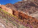
Beyond Badwater, numerous patches of deep blue to purple phacelia
were scattered along the road north to the Natural Bridge area.
We turned up the short but steep gravel road that climbs 1000 feet
to the trailhead for the Natural Bridge. Sunflowers were just
beginning to show on this fan and would no doubt increase in density
in coming weeks. The end of the road provided good views of
Death Valley with Lake Manly. Right at the trailhead, there were
numerous flowers, including patches of lupine and many of the
rare desert five-spot. A short walk up the wash led to the Natural
Bridge.
Flowers visible from the road diminished as we continued north
to the Furnace Creek area, where we picked up a copy of the
excellent wildflower guide at the Visitor Center.
For several miles north of Furnace Creek, the alluvial fans of the Funeral
Mountains to the east were sparsely covered in desert gold sunflowers.
During the next few weeks, these would undoubtedly fill in to give another
great show.
We continued on the Beatty Cutoff to the Hells Gate area, where there
were reports of blooming beavertail cactus. We searched numerous spots
in the washes along the road and found plenty of cactus budding, but
none blooming. There were many nice little groups of golden evening
primrose in bloom, however.
To end our long day, we headed west on highway 190. We stopped to
hike up the sinuous Mosaic Canyon for a mile, and then continued
over Towne Pass to Panamint Valley, where we camped along a dirt road
a couple of miles off the highway. Flowers were just beginning to bloom
here, but the views of the desert mountains in the late afternoon
light were very nice.
Our single long day in Death Valley was filled with so many marvelous
sights that it felt like several.
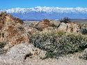
As we exited the Park on highway 190 west the next morning, we
were greeted with a clear view of the snow-covered high Sierra
Nevada crest, including the Mt. Whitney area, still in winter's grip.
California is a land of such amazing contrasts!
|
|
|
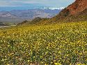
Snow-capped Spring Mtns in Nevada rise beyond desert gold sunflowers, east side of Salsberry Pass
|
|
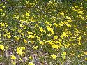
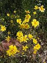
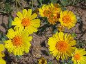
Desert gold sunflowers, near Salsberry Pass
|
|
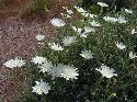
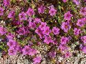
Desert chicory, near Salsberry Pass
|
|
Desert gold sunflowers, near Salsberry Pass
|
|
Desert chicory in valley west of Salsberry Pass
|
|
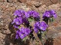
Inch high purplemat in Rhodes Wash, east of Jubilee Pass
|
|
Notch-leaf phacelia in Rhodes Wash, east of Jubilee Pass
|
|
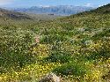
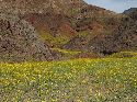
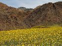
Desert gold sunflowers clothe lower slopes of Black Mtns, west of Jubilee Pass
|
|
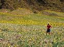
Karen admires the desert gold sunflowers at base of Black Mtns, west of Jubilee Pass
|
|
Desert gold sunflowers, base of Black Mtns, west of Jubilee Pass
|
|
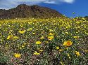
Desert gold sunflowers sweep down the fan from Black Mtns to Death Valley, snow-capped Panamint Range in distance.
|
|
Desert gold sunflowers cover a fan at the base of the Black Mtns, west of Jubilee Pass
|
|
Desert gold sunflowers frame a peak in the Black Mtns, west of Jubilee Pass
|
|
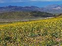
Desert gold sunflowers sweep down the fan to Death Valley with Confidence Hills in back
|
|
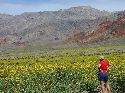
Karen admires desert gold sunflowers near Ashford Mill, looking east to Black Mtns.
|
|
Desert gold sunflowers climb fan from Death Valley floor to Black Mtns.
|

|
Amargosa River is flowing in Death Valley! Confidence Hills beyond show flower color
|
|
Shallow Lake Manly is recreated in the Badwater area below snow-capped Panamint Range
|
|
Notch-leaf phacelia forms small carpets north of Badwater area
|
|
Arizona lupine and desert gold sunflower at entrance to Natural Bridge wash
|
|
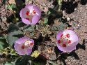
Desert five-spot at entrance to Natural Bridge wash
|
|
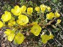
Golden evening primrose at entrance to Natural Bridge wash
|
|
Karen walks under the Natural Bridge
|
|
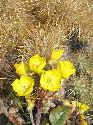
Golden evening primrose and cholla near Hells Gate
|
|
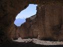
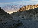
Entrance to Mosaic Canyon, looking east to Grapevine Mtns
|
|
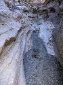
Sinuous curves in marble of Mosaic Canyon
|
|
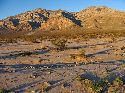
Our campsite in the Panamint Valley, looking up to Panamint Butte
|
|
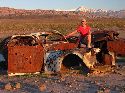
Karen admires these sleek new models in the Panamint Valley, with snow-capped Panamint Range behind
|
|
Snow covered Sierra Crest (Mt Whitney in center) comes into view as we leave Death Valley NP
|
|