|
|
Return to
WildHiker.com
->
Evolution Valley - Goddard Canyon Backpack Aug 2004
|
|||||||||||||||||
Evolution Valley - Goddard Canyon Backpack, August 2004
|
|||||||||||||||||
|
|
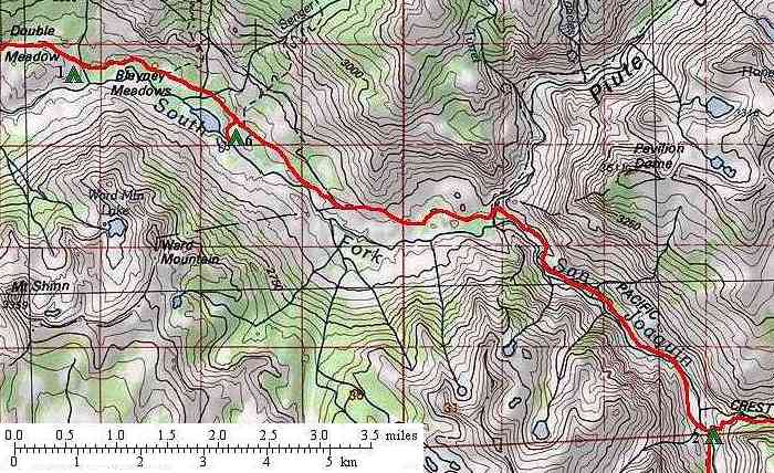
Click on any small photo to see a larger one, or view them in order: Start Here. On the second day, we picked up the trail across Blayney Meadows, where deer were common in early morning, and intersected the jeep trail again. For the next mile or so, the jeep trail, more obvious here in the forest, was generally right next to the foot trail on a nearly level course. Finally, the jeep trail headed along the flats into the Muir Trail Ranch (a guest ranch) while the foot trail climbed a couple hundred feet elevation up the canyon slope to round a spur ridge, where there was a signed trail junction for a trail down to the ranch and Blayney Hot Springs. In this section, the buildings of the ranch were visible through the trees. I'm sure the ranch provides desireable accomodations for people seeking luxury in a wilderness setting, but in so doing, they detract from the wilderness atmosphere for passing hikers. I was particularly discouraged to read on their web site that they encourage their executive guests to land their chartered helicopters at the ranch. Fortunately, there was no helicopter traffic while we were in the area! |
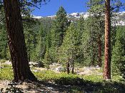 |
Just beyond the ranch, a side trail on the left is a cut-off to the John Muir Trail for northbound travelers. For the next mile, our trail continues upstream on open, lightly forested granite benches above the South Fork San Joaquin River. There are some good views through the Jeffrey Pine forest across the canyon to Ward Mountain and other peaks to the south. Our trail then just touches the river at a fine campsite against a large granite outcrop, and then heads back up onto the benches to meet the John Muir Trail, which is also a segment of the Pacific Crest Trail. At this point, we are about 6.5 miles from Florence Lake. |
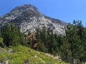 |
Heading south on the Muir Trail, we stay on the bench above the river. This area has open forest or granite slabs. Pavilion Dome comes into view as the trail approaches Piute Creek. |
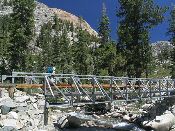 |
At about 8.5 miles from our trailhead at the Florence Lake boat ramp, the John Muir Trail crosses Piute Creek on this fancy steel bridge, leaving the John Muir Wilderness of Sierra National Forest, and entering the High Sierra Wilderness of Kings Canyon National Park. Of course, these are just labels that arbitrarily divide one great seamless wild area between different management agencies. Fortunately, the Forest Service and Park Service have compatible management for the entire High Sierra. |
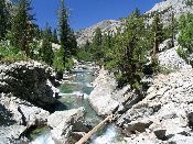 |
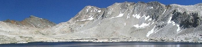
South (upstream) from Piute Creek, the South Fork San Joaquin River is now encased in a narrow granite gorge, rather than the wide valley found downstream. This view looks downstream about one mile above Piute Creek. |
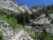 |
A little further on the John Muir Trail as it ascends the South Fork San Joaquin River gorge, we have this view south (upstream). The notch in the middle is where Evolution Creek comes in from the left. The Muir Trail will follow up Evolution Creek, while a lesser used trail -- our return route -- continues up the South Fork of the San Joaquin River in Goddard Canyon. The Muir Trail crosses to the southwest side of the South Fork San Joaquin River on a good steel bridge about midway between Piute Creek and Evolution Creek. Some campsites along the river can be accessed by following a use trail downstream along the southwest side. |
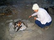 |
There are numerous campsites further upstream at the junction with the Goddard Canyon trail. The best ones, at the base of the canyon walls west of the trail, were already occupied by tents when we arrived in mid-afternoon (although we never saw their occupants). We had come about 8.5 miles today (about 12 miles from Florence Lake) and did not want to tackle the big climb up to Evolution Valley. We continued on the trail back over the South Fork San Joaquin River (to the east side) on another good bridge and camped in a well-used site along the river just off the trail. A few small parties passed us by heading on up to Evolution Valley or to nearby campsites. I think four small parties camped near us that night. Karen enjoyed a small campfire. Statistics for today: 8.5 miles of hiking, 900 feet of elevation gain, 100 feet of elevation loss. |
| Previous day | Back to trip main page | On to the third day |