|
|
Return to
WildHiker.com
->
Evolution Valley - Goddard Canyon Backpack Aug 2004
|
|||||||||||||||||||||||||||||||||||||||||||
Evolution Valley - Goddard Canyon Backpack, August 2004
|
|||||||||||||||||||||||||||||||||||||||||||
|
|
Click on any small photo to see a larger one, or view them in order: Start Here. |
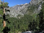 |
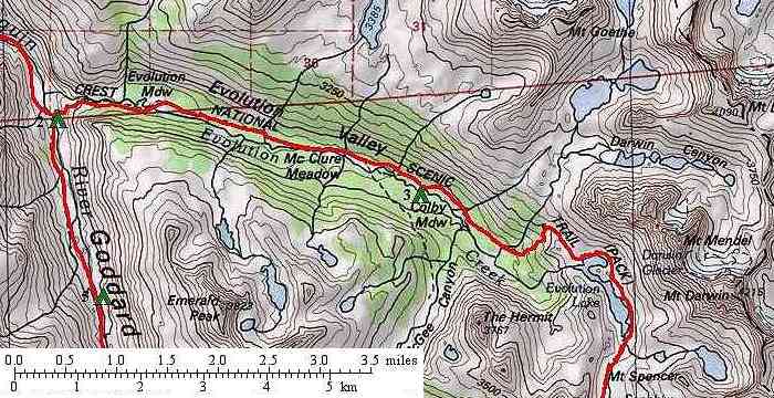
The third day of our trip will get us into the high country in Evolution Valley. On our 2002 trip over Lamarck Col, we had stayed higher, in Evolution Basin, and had not descended into Evolution Valley. I had seen many beautiful pictures of the great mountains rising above the large meadows in the valley and wanted to spend some time there. So we planned a short day of backpacking. From our previous night's campsite by the Goddard Canyon bridge, the John Muir Trail immediately started an ascent up the hanging valley of Evolution Creek. About half-way up we had this view looking north back down the South Fork of the San Joaquin River. |
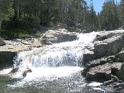 |
Because Evolution Valley "hangs" about 1,000 feet higher in elevation than the South Fork San Joaquin River gorge, Evolution Creek has many cascades and small waterfalls, like this one, as it drops down to join the South Fork San Joaquin River. |
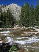 |
Approaching the "rim" of Evolution Valley, we could look back west across these cascades on granite bedrock to the far side of Goddard Canyon. The trail was well graded with switchbacks, so the climb was not onerous. We passed a few other hikers on this stretch. |
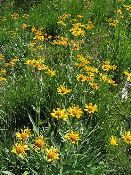 |
We saw relatively few flowers on this trip. I think we were too late in the season for many of them. These ones were growing in a damp spot near Evolution Creek. |
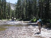 |
Once the trail finishes the climb up to the grade of Evolution Valley, it immediately crosses Evolution Creek. There is no bridge here. Karen is carefully fording the creek, which was no more than knee deep but had a rocky bottom. Our hiking poles came in handy here to brace against the current, as did the lightweight sandals I brought. I used them to protect my feet while wading across, then tossed them back over for Karen to use. This ford would be difficult, perhaps even dangerous, in early season when the creek is running full from snowmelt. |
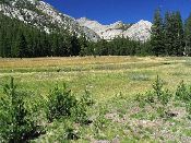 |
Just a short distance beyond the ford of Evolution Creek, the trail skirts the north side of Evolution Meadow. You have to leave the trail and walk out a bit to get good views over the meadow. This is the first (lowest) of three large meadows in the nearly flat valley, and is only about 1.5 miles from our campsite in Goddard Canyon. There were no obvious campsites here along the trail, but we did see one party with horses camped on the far side of the meadow. This view is looking west (back downstream) to peaks on the far side of Goddard Canyon. |
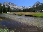 |
After hiking another two miles through the forest on a gentle grade, gaining less than 400 feet, we suddenly burst out on the edge of large McClure Meadow. A bedrock rib in the valley forms a sort of dam that created a flat area behind it that was possibly once a lake and is now the largest meadow in Evolution Valley. We stopped for a break at the banks of Evolution Creek with its gentle current and sandy bottom. This view looks south (upstream) to Mts. Mendel and Darwin (left) and The Hermit (right). |
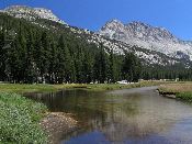 |
The John Muir trail stays along the east side of McClure Meadow and passes a small cabin that is used by Park Service rangers, although it was not occupied when we passed. We did not see anyone camped here, but it was early in the day. As this meadow had the most expansive views, I expected there would be many campers later. We decided to press on to get a little higher and perhaps find a more private site. This view shows the great cliff faces of Mts. Mendel and Darwin rising at the head of the valley. |
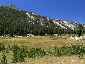 |
McClure Meadow is quite long and very flat, as shown in this view looking northwest (downstream) from near the head of the meadow. |
 |
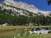
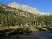
About a mile beyond McClure Meadow, after a stretch where the trail ran in the forest, we could see a large meadow off to the west while the trail stayed up on the side slope of the valley in the trees. This was Colby Meadow, the highest of the large meadows in Evolution Valley. We left the trail and walked down and across the main meadow, which was fortunately dry and not marshy. By fording Evolution Creek, which was only ankle deep here on a sandy bottom, we found a nice private campsite just in the trees on the far side and out of sight of the Muir Trail. This photo, taken in "mid-ford", looks upstream to The Hermit, which seems to rise directly above the meadow. |
 |
Because we arrived in early afternoon, we had plenty of time to rest and relax at our Colby Meadow campsite. Karen reads on a strategically placed rock along the creek, underneath the face of Mt. Darwin to the southeast. |
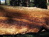 |
Weathered wood of a fallen Lodgepole Pine at Colby Meadow.
|
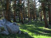 |
Our Colby Meadow campsite was in these open Lodgepole Pine woods perhaps 100 yards back from the Creek. This was really an ideal campsite, with complete privacy, beautiful views across the meadow, a lovely stream to wade in, flat areas for the tent, and a campfire ring and plenty of downed wood for the fire. If we had more time, this would have been a good base camp to explore up the side drainage of McGee Creek. |
 |
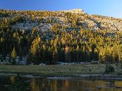
While Colby Meadow was beautiful all afternoon, it became especially attractive late in the day. The lowering sun cast long tree shadows across the meadow, with Mts. Mendel (left) and Darwin (center) rising beyond. Unfortunately, the cooling air also brought out the mosquitos that had been absent in the heat of the day. They were pesky, but not unbearable. This was the only place on the trip where we were annoyed by mosquitos. |
 |
With Colby Meadow now in complete shadow, the very low angle of the nearly setting sun pinpointed the trees on the far slope of the valley. |
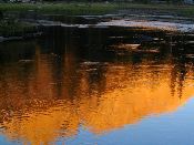 |
Photos I had seen of the meadows in Evolution Valley generally featured the colors of sunset on the surrounding peaks. I was expecting a good sunset "show" and I was not disappointed. Mounts Mendel and Darwin, rising to nearly 14,000 feet elevation to our east, were ideally situated to catch the sunset light and alpenglow. While the sun is still above the horizon, the light turns quite yellow on the peaks, which are reflected here in a pool in Evolution Creek in Colby Meadow. |
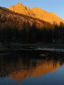 |
Here the sunset colors highlight Mts. Mendel and Darwin above Evolution Creek in Colby Meadow. |
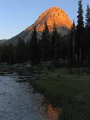 |
Turning my gaze slightly to the west showed some good color on The Hermit above Colby Meadow. |
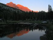 |
Finally, after the sun has set below the horizon, the highest peaks show the true "alpenglow", which is caused by the last reddish rays of the sun bending in the atmosphere. These final deep red tints of alpenglow color Mts. Mendel and Darwin above the deepening shadows of Colby Meadow. Statistics for today: 5 miles of hiking, 1,300 feet of elevation gain. |
| Previous Day | Back to trip main page | On to the fourth day |