|
|
Return to
WildHiker.com
->
Evolution Valley - Goddard Canyon Backpack Aug 2004
|
|||||||||||||||||||||||||||||||||||||||||||||||||||||||||||||||
Evolution Valley - Goddard Canyon Backpack, August 2004
|
|||||||||||||||||||||||||||||||||||||||||||||||||||||||||||||||
|
|
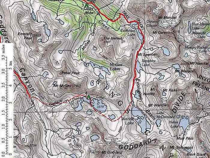
Click on any small photo to see a larger one, or view them in order: Start Here. We expected the fourth day to be the high point of our trip, both literally and figuratively. On this day, we climbed up out of Evolution Valley to the above-timbeline Evolution Basin at about 11,000 feet elevation. Evolution Basin is one of the largest of the high lake basins in the Sierra, with many very large lakes surrounded by high peaks. The scenery is stark but spectacular. We planned to hike through the basin to Wanda Lake and then start the cross-country portion of our hike over to Davis Lake, where we planned to camp. This was going to be a long day, with substantial elevation gain. But we were well rested from our short third day's hike. |
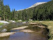 |
We got an early start, fording Evolution Creek again to get back on the John Muir Trail from our lovely Colby Meadow campsite, with this view of the crisp morning light, looking downstream. |
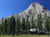 |
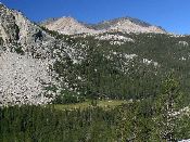
Evolution Valley continues on a gentle grade for about a mile above Colby Meadow to the headwall that leads abruptly up to Evolution Basin. The Muir Trail passes through forest and small meadows, with occasional views of the peaks, such as this one of The Hermit. |
 |
At the head of Evolution Valley, the John Muir Trail first touches a medium sized meadow stretching down to Evolution Creek, with possible camping on the far side, and then switchbacks up the eastern wall of the canyon, gaining about 900 feet elevation in a mile and a half. There are good views of Evolution Valley and surrounding peaks at several points, including this view west across to Emerald Peak. The aforementioned meadow is visible in the photo. |
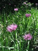 |
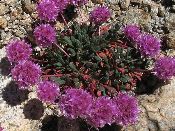
Crossing a little creeklet, I saw these wild onions flowering beside the trail. |
 |
Near the top of the climb, the Muir Trail first switchbacks near the boisterous stream descending from Darwin Bench, and then winds up past a small tarn before entering Evolution Basin near the outlet of Evolution Lake. Here we entered the grand alpine high country. There are a few scattered whitebark pines on low rises around the outlet of Evolution Lake that provide partially sheltered campsites. We did not see anyone camped there. We stopped to rest and wade in the lake. The backside of The Hermit is seen in this view to the southwest across Evolution Lake. |
 |
The John Muir Trail heads south through long Evolution Basin, passing each lake in turn. As it circles mile-long Evolution Lake, it stays high on the slope above the lake, passing through talus slopes and across granite bedrock and meadows but avoiding the fragile wet meadows by the lake shore. There are apparently some campsites on the peninsula in the middle of the lake, but we did not drop down off the trail to look. Here Karen hikes on the Muir Trail above Evolution Lake. |
 |
By the time we reach the inlet end of Evolution Lake, the very last of the trees are gone. The remainder of the day's hike will be entirely above timberline. Fortunately, we had perfect weather. This would not be a good area to hike in during stormy weather. Looking back across Evolution Lake, the cliffs of Mt. Mendel rise up about 3,000 feet. At the inlet, Evolution Creek is a wide braided stream. Large flat rocks have been strategically placed in the stream by a trail crew to let the trail cross to the west side without needing to ford. |
 |
Like most glacial lake basins, Evolution Basin has a "step and riser"
topography. There are short "risers" where the land rises rapidly a few hundred
feet up to the level of the next "step" that contains a lake. This
basin has especially large and long "steps" with low "risers", giving
it a very open and grand feeling.
Karen is on the Muir Trail as it tackles the short "riser" at the head of
Evolution Lake, with Goddard Divide in the background.
|
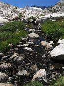 |
Evolution Creek, looking south up to Goddard Divide.
|
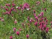 |
Lemmon's Paintbrush flowers in the meadows of Evolution Basin.
|
 |
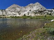
As we hiked higher into Evolution Basin, the views opened up. Here, Mts. Mendel (left) and Darwin (right) rise dramatically to the northeast beyond an unnamed lakelet. |
 |
After less than a mile, the John Muir Trail approaches Sapphire Lake. |
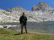 |
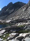
The Muir Trail touches the outlet of Sapphire Lake. Sapphire Lake was my favorite part of Evolution Basin. A side valley opens up to the east all the way to the Sierra Crest. Mt. Huxley rises as a pinnacle directly above the lake. Here I am at Sapphire Lake, with Mts. Fiske (left) and Huxley (right) beyond. |
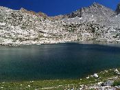 |
The John Muir Trail skirts the west side of Sapphire Lake, rising gradually up the slope rather than tackling the headwall cliff directly. A use trail branches off to follow the west shoreline and leads south to likely exposed camping spots at the inlet of the lake. About mid-way along the lake, this view looks directly east across the lake to Mts. Haeckel (left) and Wallace (middle) on the crest, and closer Mt. Fiske (right). Looking down from above like this, Sapphire Lake really shows off its namesake color. |
 |
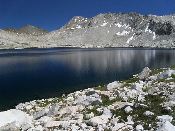
As the trail reaches the south (inlet) end of Sapphire Lake, we get a marvelously expansive view north down the length of Sapphire Lake to the high cliffs culminating in Mts. Mendel (middle) and Darwin (right). |
 |
From the head of Sapphire Lake, the Muir Trail continues for over a mile on a gentle uphill grade over open granite slopes and meadows with constant views in all directions. Flowers can be seen here and there, such as these Pussypaws brightening the granite. |
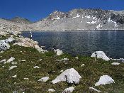 |
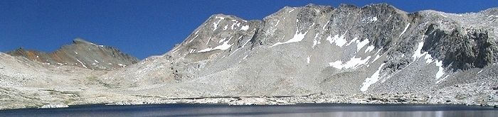
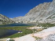
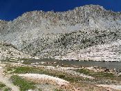
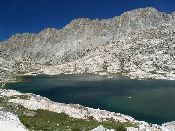
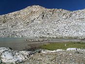
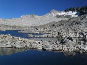
Finally, the trail reaches the shores of Wanda Lake, the largest lake in Evolution Basin -- over a mile long and about one half mile wide -- a very large lake for its lofty altitude of 11,500 feet. At this point, we have climbed about 1,600 feet elevation in about 6.5 miles from our previous night's camp at Colby Meadow. In the process, we have walked from a world of trees and meadows and lazy streams looking up to distant peaks, to a world in the peaks of rock, intense sun, and deep blue skies. Fortunately, this austere world is softened by meadow grasses and forbs that grow between the rocks and fringe the lakes. Here Karen looks south across Wanda Lake to the white granite massif of Mt. Solomons and Muir Pass. |
 |
As we head cross-country west of Wanda Lake, we look southeast across its deep blue waters to Mt. Solomons and Muir Pass.
|
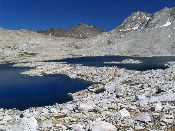 |
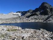
From the low divide between Wanda Lake and Davis Lake, we see a peninsula that nearly cuts Wanda Lake in two, with the Black Giant rising beyond Muir Pass.
|
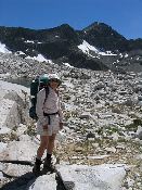 |
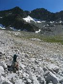
Karen at the high point of the trip (11,700 feet) on the cross-country divide between Wanda Lake and Davis Lake. Dark Mt. Goddard rises to the southwest.
|
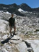 |
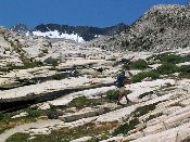
Phil at the high point on the divide between Wanda and Davis Lakes. The route leads through the jumbled, but stable talus field.
|
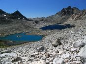 |
From the Wanda-Davis Lakes divide, looking west across Davis Lake, framed by the dramatic Pk. 12438 (left) and Mt. McGee (right).
|
 |
Karen picks her way through the talus, descending from the Wanda-Davis Lakes divide. Mt. Goddard rises behind.
|
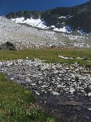 |
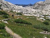
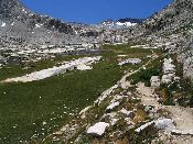
Below the talus, we are in a wide alpine valley looking southeast back up to the Goddard Divide.
|
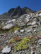 |
Numerous flowers carpet the slopes at the head of the valley above Davis Lake, including yellow Sulphur Flower, pink Pussypaws, and red Alpine Buckwheat. Mt. McGee in the background.
|
 |
Karen crosses the open meadows surrounding the unnamed lake above Davis Lake. A small exposed tent site is visible in the foreground.
|
 |
From the peninsula in Davis Lake, looking east to the low divide we crossed from Wanda Lake, with the Goddard Divide on the right.
|
 |
Karen crossing the peninsula that nearly splits Davis Lake in two. Mt. McGee rises to the north.
|
 |
Now on the north side of Davis Lake, the view across is to massive Mt. Goddard and the Goddard Divide.
Statistics for today: 9.5 miles of hiking, 1,900 feet of elevation gain, 600 feet of elevation loss. |
| Previous Day | Back to trip main page | On to the fifth day |